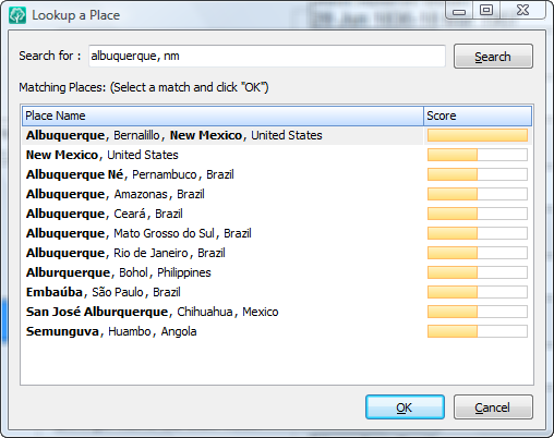
Have you ever been entering a place and wished you knew what county, province, state or country the place was in? RootsMagic 4 now provides a worldwide place database with 3.5 million places in it. Just pop up the place search and enter what you know about the place and RootsMagic will display matching places. Select a place and click OK and RootsMagic will paste the fully standardized place into the place field for you.
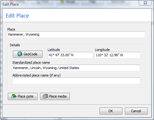
But what if you don’t want a full “standardized” place (like if you have an historical place name)? When you edit a place from the master place list, you can enter the place 1) the way you want it normally displayed, 2) as a standardized place, and 3) as an abbreviated version of the place. Of course the standardized and abbreviated places are both optional.
I’m guessing a lot of you noticed the “GeoCode” button on the Edit Place screen above. Clicking that button in RootsMagic 4 will geocode your place for you. Geocode just means that RootsMagic will check its 3.5 million place name database to find a match for your place, and insert the latitude, longitude, and standardized place name for you. Now of course we won’t make you geocode your database one place at a time. RootsMagic 4 can also geocode your entire database, and let you hand pick the places that are ambiguous.
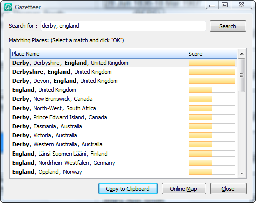
And finally, RootsMagic 4 offers a gazetteer on the tools menu to look up any place in the world.
We know how much current RootsMagic users like the free PlaceFinder program we’ve included all these years. Think of the Gazetteer as a world-wide PlaceFinder on steroids. Like the Place Search above, just type in as much of the place as you know and click Search. The Gazetteer will show you all matches, and will even let you view an online map of any of those matching places (you need to be online to view the online map of course).
Think we’re done with places? You’ll need to check out my next blog entry to find out.


Would love to have the RM4 and it seems interesting since I love Roots Magic, too.
Wish there is an interpreter for me since i am total deaf as for going to workshop, hard to hear every one talk beside an interpreter is cost to hire, tho. As far I am only deaf person who have Roots Magic.
Thank you for showing what the blog of Rm4.
Thelma Dowds
Okay, okay, okay. This sounds like a MAJOR upgrade and I think we’re all enticed enough–when is this new feature loaded RootsMagic going to be available? Please, please, please — hurry!!!
What an excellent addition! I’ll definitely enjoy this feature.
Now the rest of the world can also take advantage of what we here in the States have been enjoying with the Place Finder app (but taken to another level).
Will this allow more searchable place names? In place list I would like to be able to print all events in a single place and say New York and have it include everything that happened in every city and county in New York not just what happened only in listings of New York. Something that is not available now.
All my Christmas’ in one…….Although I hope I don’t have to wait that long.
I can see there is going to be a lot of work be done when RM4 comes out and I do hope there might be some utilities to ease the transfer to this concise place listing, I for one have a lot of street names, hospitals and cemeteries at present in my place list that need cleaned.
I also have a database of 65K townlands in Ireland that I hope can be added if they are not already there, kinda like an add on as a custom spell checker.
This is going to be one great upgrade, well done our Bruce.
This sounds like a great feature. However, a huge hot button issue for me is that the “standardized” place names do not include identifiers such as “County” or “Parish”, etc., e.g., Clinton, Anderson County, Tennessee. Similarly, I do not want to include “United States” at the end of every U.S. place name.
Will there be any customization available in the new feature to accommodate my preferences in this regard?
This is a great addition. I have loved using Place Finder for years and would use the Family History Library Catalog to try and get the proper format for foreign places. It will be wonderful having all part of the same program and not have open additional programs on the side for the most part.
I’ll have to admit though, this waiting for the release is hard on the blood pressure. haha
Looks like a great feature and something I’ve never really used before. I am now actually getting excited by a computer prigram. Is there something wrong with me? This blog thing is a great idea….
There are several different formats used for GEO codes. The one in your example is not the most popular. Will your program display GEO codes in other formats.
Any chance this place finder will include cemeteries or is this for version 5?
I still love it either way.
Jerry I think you can customize the standard place name in the Edit place screen if I read this right. I also like to use county and parish if I know it. The other think I run into is in townships. For example the standard place will show the township like it is a city; Van Buren, Keokuk, Iowa, USA. My personnal preference is to have it show as Van Buren Township, Keokuk County, Iowa, United States. It makes it alot longer but feel it points to the place better.
OK, Bruce, you’ve sold it to me so add me to the upgrade list now! As a One-Name Study person with emigrants from the UK to Australia. United States and all over the world this will be extremely useful.
I presume we will be able to add our own customised gazetteer of place names outside the standardised list, eg. I doubt if you will have “Coves, Newlandside, Stanhope, County Durham, England”, and that these new entries can be saved in a user-defined area?
Happy Paul 🙂
Will the GEO codes be viewable in Y-X format in addition to values shown in the screenshots like GEO codes are shown at maps.lds.org when you place a marker on a map.
This is an excellent new feature, however, I would like to plead for preference setting that would REVERSE the standard way of listing a place as you have it. Obviously, this is by far the most common way of listing a place (smallest geo area to largest), however, I find it phenomenally more useful to list places in reverse (largest to smallest).
Examples:
GERMANY, Rhineland-Palatinate, Germersheim, Kandel, Kandel Lutheran Church Cemetery
UK, England, South Yorkshire, Sheffield, Broomhall
USA, NC, Caldwell County, Lenoir, Belleview Cemetery
Reason, you ask? Because in the Place List, I can, at a glance, tell how places are related and have a rough idea of how near each other they are. This is particularly useful for unfamiliar places I’ve never been. Countries first, followed by County, Parish or similar unit, followed by City/Town/Township, followed by Area/Building/Organization. It’s a typical search tree.
Another example:
USA, NC, Forsyth County, Winston-Salem, Baptist Medical Center
USA, NC, Forsyth County, Winston-Salem, Forsyth Memorial Hospital
Even if you’ve never heard of either hospital, and had never been in North Carolina, you would know, at a glance, that they are in the same county and state. If they were shown in the Place List the “Normal” way:
Baptist Medical Center, Winston-Salem, Forsyth County, NC, USA
Forsyth Memorial Hospital, Winston-Salem, Forsyth County, NC, USA
… then one would show up in the ‘B’s while the other way down in the ‘F’s. Unfamiliar with Forsyth County, NC? Then, you’d have no immediate clue that the two places were near each other.
One more comment on my “REVERSE” way of listing places — it makes it a **whole lot** easier to:
(1) catch misspellings
(2) locate duplicates that aren’t obvious when listed in the “normal” order
(3) prevent auto-complete errors
On that last one, if you have Wilkes County, Georgia and Wilkes County, North Carolina in your Place List, and you’re typing fast but not paying close attention, then RootsMagic will auto-complete with the Georgia entry if you don’t keep typing to completion. What if you meant North Carolina, but didn’t notice? Whoops!
C.R, I understand your plea and the usefulness of the reverse listing but this is a great step forward in helping the global standardisation of place notation and I hope all gen programs adopt a similar approach.
The variation in the way places are recorded is very frustrating and time consuming when importing data from other researchers, this approach might take years to bring about more standardised data but it is very much needed.
Reversing the listing I agree is very useful and has been asked for many times, I am sure there will be something more in RM4 regarding places to help manage the lists we have, in the meantime I export mine to a .csv file, open it in a spreadsheet program and then sort it whatever way I like. Hope this helps.
I agree with GaryT’s request to have the option of showing the geocode info as decimal values. Mapping services such as Google seem to use this format. Will the GeoCoded info be included in an exported GEDCOM (a la Legacy)?
How cool. I guess that means I can uninstall PlaceFinder.
Also, I’ve noticed in the census that there will be precincts within the cities, and I’ve included them. Example – Pct 6 (part), Sulphur Springs, Hopkins Co, Texas
I hope that we can add those in also.
As far as place names – I hope townships will show up in the place listings at some point, but I’ll survive it they aren’t.
(I generally put ‘co’ or ‘twp’ or ‘par’ in the place, so I can tell them from other placenames.)
Reverse listing – if you print your place list to a file, you can get it in largest-to-smallest order automagically in RM3.
GeoCode: whatever program you put it in *ought* to be able to handle both DMS and decimal degrees. Or you can get a scientific calculator that will do the conversion – I have a Casio, runs about $15, that does it just fine – and enter it yourself.
(Whatever you do, try to make it the same for all the placenames, because cleaning up long lists is a pain.)
I use Family Atlas to generate maps using my Roots Magic data. How much overlap will there be between this new feature and Family Atlas?
To C. R. Andrews. I agree completely with your preference of listing places from the largest to the smallest. Also, on the Family Group Sheet, I would like to see the place name come before the description of the event (rather than tacking the place name onto the end of the description) so I quickly can see that my person is where he should be.
I use the Place Finder you included with RootsMagic a lot, but where it falls down (and where most atlases don’t help) is with townships. I know there is a very $$$ book of township maps for the U.S. out there, but I don’t have that book. Are you adding township/county/state to the search possibilities? Also, please, Please, PLEASE don’t remove the word Co. (or County) from the standard addresses — I am so tired of looking at other people’s research on places like RootsWeb and not being able to tell if they are talking about Des Moines Co., Iowa, for example, or Des Moines, Polk Co., Iowa. There are too many cases of towns with the same names as counties, or townships with the same names.
I just tried out the geocoding interface in the preview …
It took about a minute and gave me a list of all the “goofy” place names in my database so I could review them and clean them up. I can’t wait until I can do this on my “working” database!
Charlou, I’ve even considered (and I still might do it) buying all the USGS quads on CD (National Geographic has them) and writing down every one of the township names, just to have a list (for states that have named townships, anyway).
I also agree with you about county names – I have a number of them from imported files where I can’t tell if it’s a town or a county name (sometimes it doesn’t matter, but not usually). Some even are missing the state, or the country.